The idea behind the ‘Geocross Trail’ series is to find features using OS map and GPS skills.
The idea was conceived during the Covid Epidemic and lockdown of 2020 when geocaching became unattractive because it encouraged contact.
It is similar to geocaching except that no contact is required, there are no hidden Tupperware boxes with treasure and no signing-in sheet. You will visit some interesting features and learn a lot about the history of the Peak District.
You will need the relevant Peak District North or South OS map at 1:25000 scale and a compass, and a GPS device like a smart phone.
Each Geocross visits a series of features at from 5 to 20 locations. You can plot your course before starting using the 10 figure grid references provided in the table below.
At each location you can use your GPS device and the What Three Words (W3W) app to fill in the missing second and third words in a table like the one below:-
| Location | OS grid reference | W3W | ||
| First word | Second word | Third word | ||
| 1 | Dale Dyke Memorial SK 24288 91795 | umbrella | ||
| 2 | Bridge over Dale Dyke SK 21995 90485 | flaunting | ||
| 3 | Sheffield Country Walk SK 23756 90786 | memory | ||
| 4 | Boots Folly door SK 23042 89905 | define | ||
| 5 | Broggin House SK 23059 90646 | volume | ||
| 6 | Highfield House SK 23441 91488 | tanks | ||
| 7 | Emlin Dyke weir SK 24855 92814 | launched | ||
| 8 | Agden House gate SK 25056 92986 | silver | ||
| 9 | Scenic bench SK 25394 93324 | movies. | ||
| 10 | Rocher Head farm SK 25742 93538 | slimy | ||
| 11 | Bailey Mound east SK 26619 92644 | name | ||
| 12 | Bradfield Church SK 26740 92554 | fallen | ||
| 13 | The Watch House SK 26752 92536 | mouth | ||
| 14 | Damflask Village sign SK 28248 90854 | lived | ||
| 15 | Damflask Reservoir SK 27622 90523 | cave |
The ‘cross’ part of the Geocross is a crossword like the one below:-
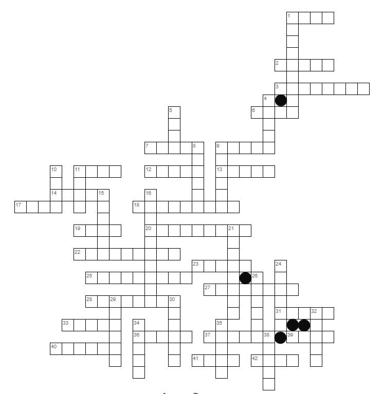
The crossword is not essential, it’s just a bit of fun
To solve this crossword puzzle you need to visit the locations of the main feature in the photographs.
You will need the what3words app (W3W) on your GPS device. Using your GPS device held over the main feature you then get the what3words address. You will probably have to move around to find the W3W square containing the ‘word’ provided.
You may prefer to take a W3W photo which has the option of showing the W3W clue, and fill in the table after completing the trail.
Save all the words and eventually fit the words to the crossword grid. For the example above you will visit 15 locations and collect three words at each. You will be given at least three words as ‘clues’ which will get you started on the crossword
In order to help you ensure that you obtain the correct three word (W3W) address, the first word in the W3W is provided as a clue. You may need to walk around the main feature into different 3 x 3 metre grid squares to find the correct W3W address.
E.g. Let’s assume that you are at a location given by the W3W address thick.verge.commented and you are told the first word of the W3W address is the word “thick”. You now know you have found the right one.
Each of the locations can be found on the map provided. The locations are listed in order and sufficient background is included to help you triangulate your position to identify the location
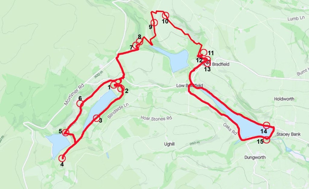
The trails are usually circular so start and finish can be at the same location.
For each trail an approximate distance is given and a Difficulty grading depending on the type of terrain.
Difficulty
Easy / Moderate / Difficult / Hard
Safety
Remember that you are responsible for your own safety.
There may be some precarious locations.
